If you have a query please check the FAQs below to see if we have an answer for you. If you still need help, please contact us at support@nbn.org.uk or call us on 0115 850 0177
GENERAL QUERIES
How do I register for the NBN Atlas?
Just click the Login tab at the top right of the home page. You can login through Facebook or Google, but we would recommend that you set up an NBN Atlas account as this will give you greater permissions. (Note: you may need to check your spam folder for the account activation email which can take a few minutes to arrive)
If you receive an ‘Error 500’ message after registering this may be because your email address is already registered on the NBN Atlas. Please try entering your email address and chose the option ‘forgot password’ if necessary on the log in page.
Where can I find the terms and conditions for the NBN Atlas?
Please take the time to review the NBN Atlas Terms of Use.
Can images be downloaded and are there any copyright issues?
Yes, users will need to abide by the conditions of the associated CC licence for the image
Can I see the common rather than scientific names of species?
Yes, you can search by either common or scientific names and both will be displayed on the species pages. Use the filter options available.
How is the NBN Atlas funded?
In partnership with the National Biodiversity Network Trust (NBN Trust), a registered charity, the funding for the original development of the infrastructure was provided by Natural England, Scottish Natural Heritage, Natural Resources Wales, the Welsh Government and Scottish Environment Protection Agency. Additionally the Northern Ireland Environment Agency, Manx National Heritage, Isle of Man Government and the Manx Wildlife Trust have provided funding.
In April 2019 the NBN Trust received a National Lottery Heritage Fund grant of £190,500 which will help to further develop the NBN Atlas.
Who supports the NBN Atlas?
The National Biodiversity Network Trust (NBN Trust), a registered charity provides the day to day support and management of the NBN Atlas. The NBN Trust is responsible for facilitation and management support, responding to queries, uploading data, providing user support and developing enhancements. The NBN Trust works to promote the NBN Atlas, biological recording and data sharing. The NBN Trust receives no guaranteed funding and relies on donations and the support of our network of members and data partners.
To find out more about how to provide your support by becoming a member or making a donation please visit the NBN Trust website.
How do I keep up to date with developments of the NBN Atlas?
You can keep up to date with developments to the NBN Atlas by signing up to Network News, the NBN Trust’s monthly newsletter or visiting our website. We have also set up a Message Board which can be accessed through the Help menu. We will use this to list any system updates or significant developments that users need to be aware of.
FAQs
DATA RELATED QUERIES
Can I upload data directly to the NBN Atlas?
At the moment data needs to be sent to data@nbnatlas.org You can read about how the data should be formatted in the Provide data section of the website. Alternatively you can submit data through iRecord.
One of the areas for future development is the ability to upload data directly to the NBN Atlas.
Are there any access controls on the NBN Atlas?
The only access controls on the NBN Atlas are for sensitive species. Requests for access to enhanced datasets for all non-sensitive data will need to be sent direct to the data provider. Their contact details are available on the NBN Atlas
Open access
Taking the views of the range of NBN members into account the NBN Atlas is open access by default, except in relation to sensitive species, as explained above.
Every record that is held on the NBN Atlas is licensed with one of three Creative Commons Licences or an Open Government Licence (OGL). The Creative Commons Licences offered are:
- Creative Commons Zero (CC0)
- Creative Commons with Attribution (CC BY)
- Creative Commons, with Attribution, Non-commercial (CC BY-NC)
You can find out more information on Creative Commons licences and more information on licensing on the NBN Atlas here.
Important note:
Just because data is openly published it has no implications for public access to species which may have been recorded on a particular piece of land that is privately owned. Please make sure that you do not trespass on private land.
If you are keen to get involved in recording please refer to our database of surveys and recording schemes for more information about groups in your area.
How are sensitive species data handled?
Sensitive species data can be submitted to the NBN Atlas at capture resolution and it will be automatically blurred on upload to the resolution specified on the sensitive species list for each country. Find out more about the treatment of environmentally sensitive data on the NBN Atlas.
Who can see or download my data?
Anyone will be able to view the data on the NBN Atlas. When requesting a download they will have to log in and provide their contact details and a reason for download.
Will I be able to see who downloads my data?
Yes, there will be data usage stats on the data partner page
Can my data be downloaded for commercial use?
This will depend on the licence attached to the dataset. The only licence that does not allow commercial use is the CC BY-NC licence.
How do I only download data without a CC-BY-NC licence?
Before completing your download ensure that you select only data with the relevant licence conditions. You can find out how to do this here.
Is data verified before upload to the NBN Atlas?
Data on the NBN Atlas will be flagged as either verified or unverified. Further information on verification terms is available.
How can I find out more about searching and analysing the data?
There is a separate section for help with analysing data, which we will continue to add information to.
Is there a charge for using this data?
There is no charge for using this data. However as a charity we are only able to provide our services through the support of our members or donations. Please show your support when using data from the NBN Atlas either by becoming a member, corporate supporter or making a donation.
FAQs
TECHNICAL QUERIES
Can I use rNBN with the Atlas?
Not at the moment, it needs updating, but will be coming soon
How do I use web services?
Guidance for using web services will be available soon. In the meantime you can find out more about using the API
FAQs
MAPPING QUERIES
NBN Atlas Cartographic Functions
This information covers techniques for reproducing maps for publication or websites. It does not cover whether you have the required permissions to publish or reuse any maps that you create. Please refer to the relevant sections in the NBN Atlas terms of use for further information on this.
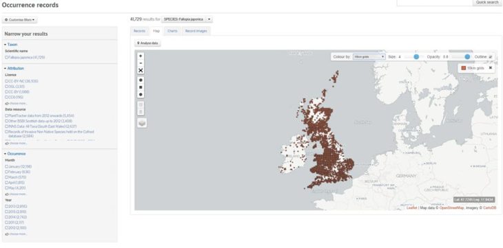
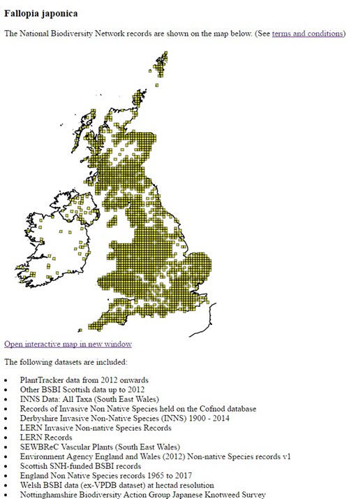
The following examples all require the ‘Taxon version key’ for the entity to be mapped. One simple way to get this is to look up the species in the NBN Atlas and examine the url. For example, a search for Japanese Knotweed will return a link to the following species overview:
https://species.nbnatlas.org/species/NHMSYS0000458716
and the required ‘key’ is the sequence of numbers and letters beginning NHMSYS… Alternatively, you can click on the species page and then click on “Names” where you will find the Taxon version key listed at the bottom of the page.
To create the map image use Mac Shift+Cmd+4 or Windows 10 ‘Print Scrn’ and save the image as a file.
e.g. https://records.nbnatlas.org/occurrences/search?q=lsid:NHMSYS0000458716#tab_mapView
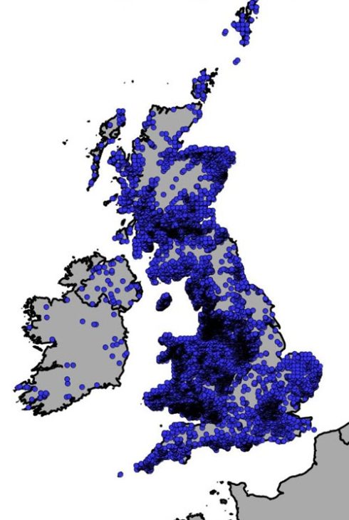
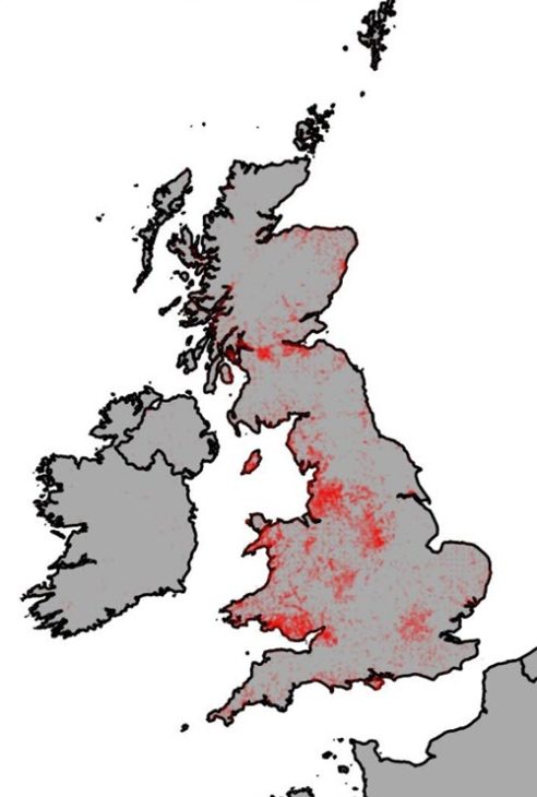
When you arrive at the map page, it will default to “Colour by – Variable grids” If you select 10km grids, the appearance of the map will change as follows:
Producing an image from Export Map function
The ‘Analyse’ data spatial interface has an “Export->Map” function that can also produce images. More information can be found in Help with analysing data.
Producing an image from EasyMaps
The EasyMap Software Shim replicates, to a large extent, the most popular mapping features of the NBN Gateway’s original EasyMap solution (for documentation of the various options, see the EasyMaps help pages) and can be used to produce maps and associated text for use in client websites.
https://easymap.nbnatlas.org/EasyMap?tvk=NHMSYS0000458716&w=800
Alternatively, by replacing the term “EasyMap’ in the url with “Image” a png image is returned.
https://easymap.nbnatlas.org/Image?tvk=NHMSYS0000458716&w=80
The original EasyMap solution limited the width of the image to 800 pixels. This revised version maintains this limitation, but allows an addition “&retina=2” parameter to be appended to the url. This will double the resolution of the returned image. When used on a EasyMap page the image will remain the specified size, with the double resolution image scaled to fit accordingly. This can result in ‘cleaner’ images without breaking the original API specification.
https://easymap.nbnatlas.org/Image?tvk=NHMSYS0000458716&w=800&retina=2
In order to optimise response times both html and image are cached for one month. To force an update, the flag “&cachedays=0” can be added (although this is not normally needed nor generally recommended since it will slow response times as everything will be regenerated).
Other mapping capabilities
More sophisticated mapping capabilities are available in the Generate Static Map web service (see https://api.nbnatlas.org for documentation).
For example:
Finally, WMS (‘slippy’) maps are available for web developers to create their own interactive experiences. This is documented under the Mapping subheading (https://api.nbnatlas.org). For an example, please see: https://duncanrowland.github.io/NBNMapOverlayExamples/leaflet3.html
Mapping species
Specific queries for using the maps can be found in the Help with analysing data section.
Is there a charge for using these maps?
There is no charge for using these maps. However as a charity we are only able to provide our services through the support of our members or donations. Please show your support when using data from the NBN Atlas.